“We tend to underestimate the geographical knowledge of past societies. This slab is important, as it highlights this cartographical knowledge.”
National Institute of Preventive Archaeological ResearchFound in 1900, the Saint-Bélec Slab was never properly analyzed until now.
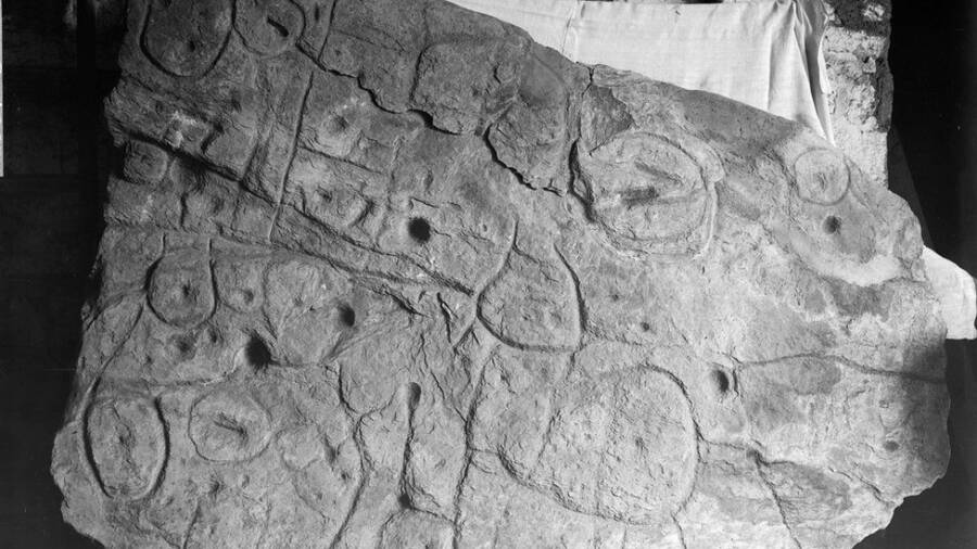
In 1900, archaeologist Paul du Chatellier was excavating a prehistoric burial ground in northwestern France when he made the discovery of a lifetime, unearthing the Saint-Bélec Slab. The Bronze Age piece of rock was covered with odd markings that have only now been revealed as Europe’s oldest 3D map.
It’s no wonder why experts failed to properly analyze the find before, according to the BBC. The Saint-Bélec Slab seemed to vanish after its excavation. Initially acquired by a private collector, it was bought by France’s Museum of National Antiquities and then lay buried in the moat of a castle until 2014.
Rediscovered by dedicated archaeologists, the remarkable Bronze Age rock has been pored over ever since. According to The Independent, the Saint-Bélec Slab has been dated to the Early Bronze Age, between 1900 and 1650 B.C., and is thus officially t7he oldest map ever found in Europe.
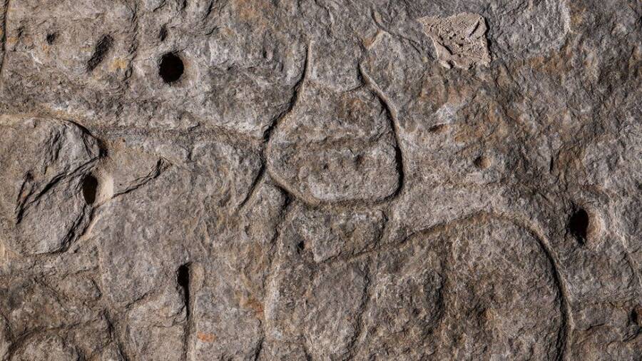
While that’s certainly fascinating on its own, the weighty map’s engravings are even more astounding. As a study published in the Bulletin de la Société Préhistorique Française explained, the slab showed an area of 13 by 18.5 miles — with motifs that detailed roads, settlements, rivers, and a burial mound.
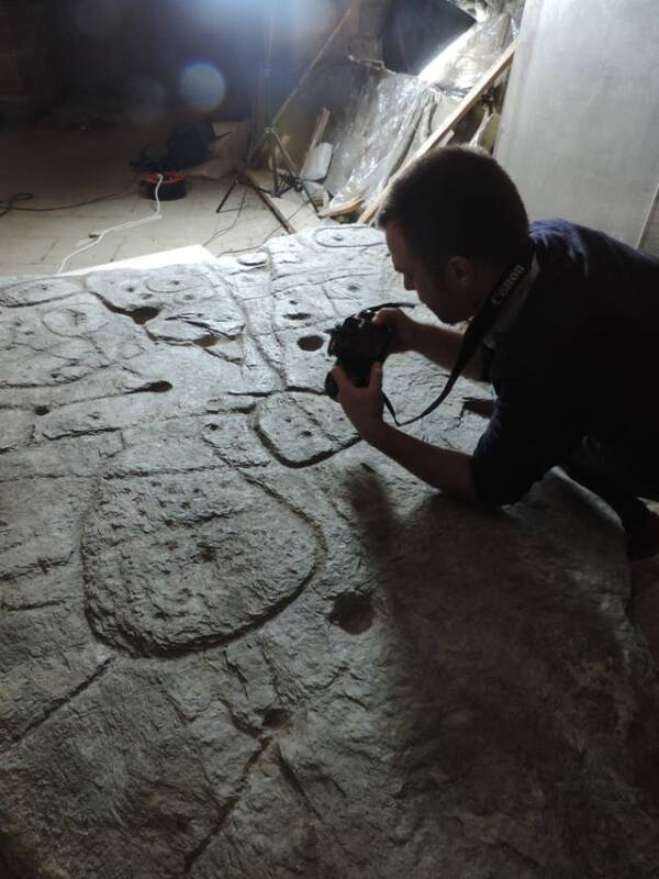
France’s National Archeology MuseumResearchers photographing the carvings in 2017.
It’s unclear if Paul du Chatellier was aware of the rock’s age when he found it, but the 1900 discovery was certainly exciting enough for archaeologists to vie for it. After unearthing the slab during excavations in Finistère, on the French peninsula of Brittany, du Chattelier sold it a private museum for a presumably hefty sum.
Although France’s Museum of National Antiquities acquired the item in 1924, it was later buried in a chateau moat until the 1990s. As the BBC reported, the Chateau belonged to du Chatellier himself — suggesting reacquisition or some sort of agreement allowing him to guard it.
Ultimately, the remarkable item was rediscovered in the cellar of that castle by obsessive researchers in 2014. While it was clear that the slab dated to the Bronze Age, the significance of its carvings was only discovered in 2017, using even more modern technology.
High-resolution 3D scans brought millennia-old mysteries to light and showed clear motifs that experts have since interpreted as specific locations. From the center of the settlement — which was situated where the Odet, Isole, and Stêr Laër rivers converged — they identified river networks, roads, fields, and more.
Experts deemed the roughly 19-mile map of Finistère to be 80 percent accurate.
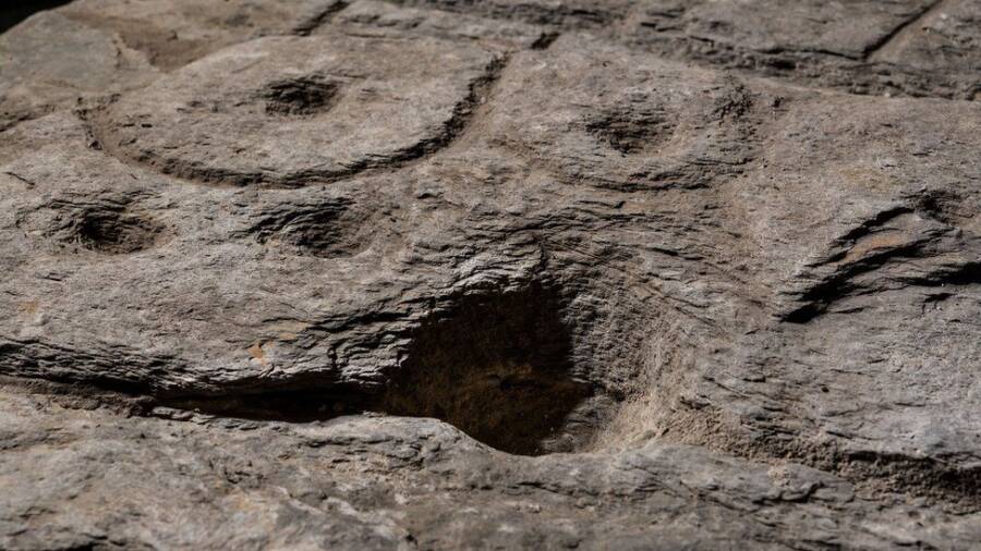
National Institute of Preventive Archaeological ResearchThis particular crevice perfectly matches a particular stretch of the River Odet valley.
“This is probably the oldest map of a territory that has been identified,” said Dr. Clément Nicolas, of Bournemouth University. “There are several such maps carved in stone all over the world. Generally, they are just interpretations. But this is the first time a map has depicted an area on a specific scale.”
Nicolas is one of many experts who joined in the endeavor to analyze this map. Scientists from the University of Bournemouth and French National Institute for Preventative Archaeological Research, the French National Center for Scientific Research, and the University of Western Brittany were also on board.
On its face, the Saint-Bélec Slab itself is nothing but a well-preserved piece of old rock that is six inches thick and measures five by six-and-a-half feet. In proper context, however, it connotes just how sophisticated prehistoric societies really were in their understanding of cartography.
According to Bournemouth University, it was made around the same time of the Nebra sky disk, which depicts the cosmos and was found in Germany in 1999. While the slab was found to have been used in a Bronze Age burial to form one of the walls of a coffin, experts are most curious about its political use.
National Institute of Preventive Archaeological ResearchThe map was found to represent a Finistère area measuring 13 by 18.5 miles with 80 percent accuracy.
“It was probably a way to affirm the ownership of the territory by a small prince or king at the time,” Nicolas said. “We tend to underestimate the geographical knowledge of past societies. This slab is important as it highlights this cartographical knowledge.”
Just as the slab’s knowledgeable depiction of the territory was used as a sign of power over the area, so would its burial suggest a trouncing of the elites who reigned over it. According to Bournemouth University researchers, at least, burying the rock may have signaled the end of a ruler’s reign.
Ultimately, researchers are overjoyed at the sheer preservation of this item. The Saint-Bélec Slab showed little, if any, weathering at all, which suggested that it had been buried shortly after it was made. With the cool and dark environs of various museums and a castle cellar, that certainly makes sense.
After reading about the Bronze Age stone slab found in France, learn about researchers finding the oldest-ever bracelet alongside an extinct human species. Then, read about the world’s oldest beer brewery, unearthed at an ancient Egyptian burial site.