Ancient Irish incest uncovered, buried Roman city found, mysteries of China's Great Wall unlocked.
5,200-Year-Old Irish Tomb Reveals Evidence Of Vast Incest Ring Among Ancient Royals

Wikimedia CommonsThe 5,200-year-old Newgrange tomb in County Meath, Ireland has unlocked untold archaeological mysteries over the years.
Archaeologists working inside the ancient Newgrange tomb in rural Ireland recently found remains that revealed an ancient king who was the product of incest. Moreover, samples from Neolithic sites across the country found evidence of rampant incest among the country’s ruling elites some 5,000 years ago.
Researchers had found virtually no evidence of royal incest in the country before and were shocked by the new evidence, saying, “I’d never seen anything like it.”
Discover more about what researchers found.
Researchers Use Lasers To Map Buried Ancient Roman City That Dates Back 2,300 Years
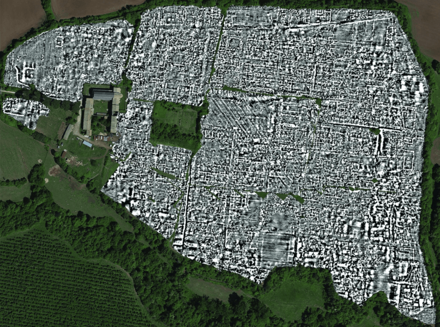
Verdonck et al., 2020/AntiquityFalerii Novi was populated by around 3,000 people and contained a theater, shops, and monuments.
For the first time in history, archaeologists have mapped an entire ancient Roman city using ground-penetrating radar. The buried town of Falerii Novi contained a bathhouse, theater, several temples and shops, and a large monument unlike anything experts had ever seen before.
Once a proud, 75-acre outpost 31 miles north of Rome, Falerii Novi was built and occupied in 241 B.C. and abandoned in 700 A.D. Though it’s been thoroughly buried over the course of time, new technology has allowed experts to see through layers of ground and map the town in detail without digging.
Dig deeper in this report.
The Great Wall Of China Wasn’t Built To Keep Out Genghis Khan — But To Control Nomadic Shepherds
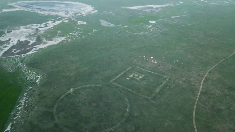
Gideon Shelach-Lavi et al/Hebrew University/Antiquity JournalThe research team used unmanned aerial drones to survey the wall and forts seen here.
For the first time in history, experts have mapped all of “Genghis Khan’s Wall,” a 458-mile stretch of China’s Great Wall in Mongolia. The study found this fortification wasn’t built to stave off invading hordes after all — but instead to manage nomadic shepherds.
The joint effort on behalf of researchers from Yale University and the Mongolian Academy of Sciences used unmanned aerial drones to survey the territory. The findings starkly contradicted previous theories that this section of the wall was defensive in nature.
Read on here.